
A late-November garden can make a weather report feel personal. The forecast says the low was 36 degrees Fahrenheit. The porch thermometer agrees. Nothing, according to the numbers, should have frozen. Then you step outside and the lawn is silvered, the fallen oak leaves are rimmed white, and the low parsley at the edge of the path looks as if it has been dusted with glass.
This is one of the small arguments between official weather and the actual garden. The thermometer was not necessarily wrong. The frost was not imaginary. They were simply measuring different things in different places.
Frost is a surface event. White or hoar frost forms when water vapor deposits directly as ice on a surface that is at or below freezing and at or below the air’s frost point.1 A weather station, a phone app, and a porch thermometer tell you something useful about the air where it was measured or forecast. A blade of grass, a leaf, a roof, or a low bed can be colder than that air on a calm, clear night. Surfaces have their own energy balance, and frost is one way the garden reveals it.
The thermometer is not on the grass
Official air temperatures are not taken at grass height. The National Weather Service explains that standard observations are made in a shelter roughly four to six feet (1.25 to 2 meters) above the ground, and that frost can form while the reported air temperature is above freezing because the surface below can be colder.1 That one detail explains many morning surprises.
A thermometer is honest only about its own location. If it is mounted near a wall, under an eave, on a porch, or several feet above the soil, it may be warmer than the grass tips. It may also be influenced by the house, stone paving, stored daytime heat, or air movement. Meanwhile, the exposed leaf at ground level is living in a thinner, colder layer of air.
This matters in gardens because plants do not experience the forecast as a single number. A tomato leaf, a strawberry crown, a low basil plant, and a branch six feet above the ground can each meet a slightly different night. Frost is often local before it is universal.
Clear nights let the ground lose heat
The main engine behind this kind of frost is radiational cooling. The National Weather Service describes clear skies as favorable for radiational cooling: exposed surfaces emit longwave radiation toward the sky and cool.2 Clouds absorb and emit longwave radiation back toward the surface, slowing that heat loss. A clear sky lets the garden cool more freely.
On a calm, clear night, a leaf can lose heat faster than the air around it. The surface temperature of the leaf drops. If it reaches freezing and cools to or below the air’s frost point, water vapor can deposit as ice.1 The reported air temperature may still be in the mid-30s because the official reading is taken higher up and in a standardized setting.
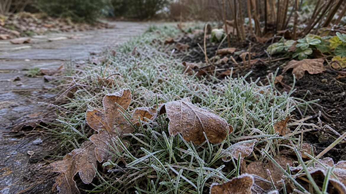
This is why frost often appears first on open lawns, roofs, cars, mulch, and exposed leaves. Those surfaces have a clear view of the sky and little shelter from radiational heat loss. A plant tucked under a tree canopy or close to a warm wall may escape the same night with no frost at all.
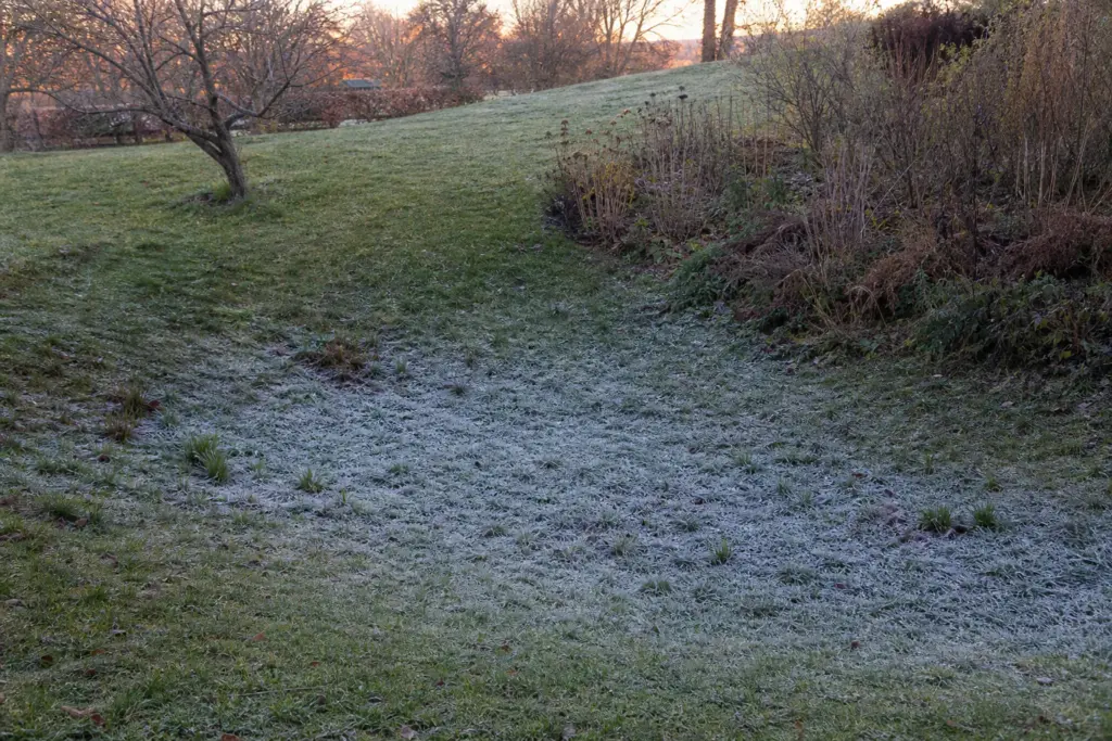
Cold air sinks into the low places
Radiation is only part of the story. Cold air is denser than warm air, so it tends to drain downhill and settle in low spots. The National Weather Service notes that on clear, calm nights, cold air can sink to ground level, making grass-blade temperatures colder than the air a few feet higher.3
Gardeners know these places even if they do not name them. The bottom of a slope. The dip behind a hedge. The low bed beside the driveway. The corner where fog lingers. The vegetable patch that frosts before the herb bed near the kitchen wall. These are frost pockets, and they can be surprisingly consistent from year to year.
Cold air also needs somewhere to go. A solid fence, dense evergreen hedge, raised wall, or piled-up brush can slow air drainage and let cold air pool behind it.4 That does not mean every barrier is bad. Windbreaks have their own uses. But a barrier in the wrong place can turn a bed into a small basin of cold air.
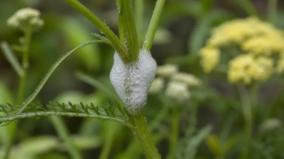
Moisture decides whether the cold becomes visible
A cold surface alone is not enough to make a white morning. Water vapor must also be available, and the surface must cool to or below the frost point. The National Weather Service describes frost as solid deposition of water vapor and notes that favorable moisture and light-wind conditions matter alongside the temperature of exposed surfaces.15
That is why two cold mornings can look different. A dry, breezy night may chill tender plants without leaving much white. A humid, calm night may draw frost crystals onto every blade of grass. Frost is not simply cold made visible. It is cold, moisture, exposure, and stillness working together.
Dew and frost are related, but they are not identical. If a surface cools to the dew point while still above freezing, water condenses as liquid dew. If water vapor deposits directly onto a surface below freezing and at or below the frost point, it makes hoar frost. Dew that forms first and freezes later is better called frozen dew; it often looks slicker and lacks the branching crystals of hoar frost.1 Either result tells you about the surface, not only the air several feet above it.
Why the path edge may stay warmer
Hard materials can change a small garden’s night. Stone, brick, gravel, walls, and paving absorb heat during the day and release some of it after sunset. UC Agriculture and Natural Resources’ garden microclimate guidance notes that heat sinks such as paved surfaces, gravel, rock, and decks can absorb and reradiate heat at night, slightly increasing nearby night temperatures and reducing frost impact.4
This is why a plant against a sun-warmed masonry wall may survive a light frost that blackens the same species in the open bed. It is also why frost can make patterns. The lawn is white, but the strip beside the path stays green. The open lettuce row is glazed, but the parsley tucked near the stone step is only wet. The difference may be only a degree or two, but a degree or two is the entire question when the surface is flirting with freezing.
Microclimates can be used deliberately. Tender herbs near a heat-holding wall. Early greens in a bed with a cover ready. Fruit trees away from cold-air basins when possible. None of this defeats winter, but it can shift the odds during the borderline nights that decide what survives one more week.
Frost is not the same as a freeze
Gardeners often use frost and freeze as if they are interchangeable, but the distinction is useful. Frost describes ice deposited on surfaces. A freeze refers to air temperature at or below 32°F (0°C); a hard freeze is commonly defined as 28°F (−2.2°C) or lower for at least a few hours.5 You can have frost while the reported air temperature stays above freezing, and you can have damaging cold without dramatic white crystals if the air is dry or windy.
The National Weather Service glossary notes that frost is primarily a result of radiational cooling and can occur with thermometer-level temperatures in the mid-30s.6 That explains the warning language gardeners hear in autumn: patchy frost, areas of frost, frost advisory, freeze warning. They are not all the same level of risk.
For plants, what matters is tissue temperature, species, exposure, and how long the cold lasts. A light frost may mark only the most exposed leaves; the different response of a hardy crop is part of why frost makes kale sweeter. A hard freeze can end tender annuals even where frost crystals are not especially showy. A protected microclimate may carry greens, herbs, and late flowers through several marginal nights before a true freeze finally closes the season.
Reading your own frost map
The useful response is not to mistrust every forecast. It is to learn how your garden edits the forecast. After a clear, calm night near freezing, walk the garden early. Notice which areas frost first. Look for the low ground, the open lawn, the bed beneath the clear sky, the corner behind a hedge, the warm strip near stone, and the plants protected by canopy.
A garden frost map is practical information. It tells you where to plant the most tender basil last. It tells you where to place fall lettuce if you want a longer harvest. It tells you which containers should be moved first, where a row cover matters most, and where spring frost may threaten fruit blossoms even when the rest of the yard looks safe.
It also keeps disappointment honest. If the weather app said 36 and the dahlias still collapsed, the app did not necessarily lie. The exposed leaves may have fallen below freezing even while the forecast or shelter-level reading remained warmer. The plant met a colder garden than the number suggested.
Simple ways to shift the odds
For a light radiational frost, small interventions can matter. Floating row cover or a dry sheet can trap some soil heat if it reaches the ground and its edges are secured; support heavier material above brittle plants. Remove opaque covers after the morning warms, and vent framed plastic promptly in sun so plants do not overheat. Containers can be moved near a wall, under a porch roof, or into a garage for the night.7
These tactics are less effective in an advective freeze, when a cold front brings a deeper mass of cold air and often wind. Colorado State University Extension distinguishes these conditions from radiation frost on calm, clear nights and notes that crop protection may be questionable when an advective event drives temperatures well below critical levels.7 A cover is more useful for a marginal radiation frost than for a windy cold outbreak.
That is why watching wind and sky matters. A calm, clear night with a forecast low of 36 can be frostier than a breezy, cloudy night with a similar number. The garden is not only reading temperature. It is reading radiation, moisture, wind, exposure, and terrain.
Final thoughts
Frost above freezing is not a contradiction. It is a reminder that the garden lives at leaf height, not app height. A weather station gives you the broad story. Grass blades, mulch, stone, slopes, walls, and shrubs write the footnotes.
Once you see frost as a microclimate map, a white November morning becomes more than a warning. It is information. The garden is showing you where heat leaves quickly, where cold settles, where stone gives a little back, and where the season will always arrive first.
References
- National Weather Service: Dew and frost development
- National Weather Service: What causes frost?
- National Weather Service: How does frost form with low temperatures warmer than 32 F?
- UC Agriculture and Natural Resources: Garden microclimate site evaluation form
- National Weather Service: Freeze and frost dates
- National Weather Service glossary: Frost
- Colorado State University Extension: Frost protection and extending the growing season